· via Hacker News – Front Page (native)
48 AI agents scanning NASA lidar surface an unreported Maya pyramid in 72 hours
A blog post reports that 48 AI agents analyzing NASA lidar scans of Mexican jungle identified a Maya site with an 8–12 m pyramid, and Mexico's INAH found no registered site at those coordinates — all within 72 hours.
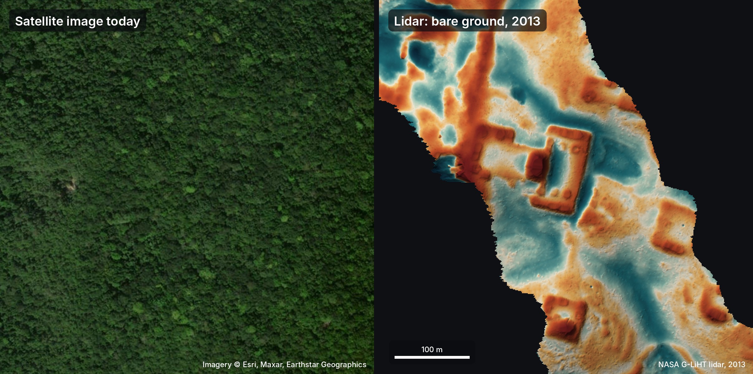
A first-person account published at pietromiotti.com reports that a swarm of 48 AI agents, set loose on publicly available NASA lidar data, identified a Maya site in Mexico that appears in no registry — a hilltop complex with a levelled plaza and an oval pyramid — in under 72 hours, from an idle travel thought to a reply from the country's National Institute of Anthropology and History (INAH). The post reached Hacker News's front page under a headline crediting Google's SWE agent software, though the write-up itself does not name the framework behind the agents. The author is candid about the limits: they are not an archaeologist, and nothing is confirmed until someone actually walks the site.
How the search ran
According to the post, the idea struck on 18 October while the author was traveling in Peru and reading about Hiram Bingham's 1911 arrival at Machu Picchu. A brainstorm across several chatbots — Gemini, ChatGPT, Claude and Grok — converged on lidar: laser pulses slip through gaps in the forest canopy and map the ground below, whereas satellite photos show only trees. Peru's public lidar coverage proved thin, so the effort pivoted to the Maya lowlands, which are far better served.
That night the agents went to work. They converted roughly 1,200 square kilometres of lidar strips into images and worked through them one by one, hunting for pyramids, platforms and plazas while discarding natural hills, sinkholes and roads. The post stresses that no custom model or classifier was involved; the agents simply inspected the imagery against a precise written guide.
What they flagged
By morning the agents had a list of candidate settlements. Asked to check them against published literature and archives, they reported that one major village seemed never to have been registered. It occupies a cliff-edge hilltop, with the straight edges and sharp corners that natural terrain rarely produces. The detailed analysis described a levelled plaza, an oval pyramid at least 8–12 metres tall, an attached raised courtyard, a flat-bottomed hollow that could have been a rainwater reservoir, and three platforms that may be house mounds.
To rule out artefacts of the canopy, the agents re-examined the raw point cloud, separating ground returns from leaves; under 10–17 metres of forest, the ground points traced the same plaza, pyramid and courtyard. The broader reading — a small civic centre from the Classic period, roughly AD 250–900, centred on a temple pyramid and possibly a ruler's residence — is explicitly labelled speculation in the post, drawn from long conversations with the models rather than expert assessment.
The paperwork, also delegated
The agents then handled the administrative end as well. They recommended contacting INAH, drafted the discovery report, supplied the relevant contact details and, on Claude's suggestion, translated it into Spanish — a language the author does not speak. The report went out on 20 October with the exact coordinates in a confidential annex. On 21 October, INAH replied that it had checked its records and identified no registered archaeological site at the location given.
That is an archival finding, not field verification. Any ground survey requires INAH's authorisation under Mexican federal law, and the decision now rests with the institute's local centre, which the author has offered to assist.
Part of a bigger pattern
The post situates the find in an established method, citing NASA's G-LiHT airborne lidar programme (Cook et al., 2013), earlier reuse of environmental lidar for archaeology (Golden et al., 2016), the 2024 lidar-based identification of a Maya city in Mexico (Auld-Thomas et al., 2024), lidar-derived population estimates for the Maya lowlands (Estrada-Belli et al., 2025) and a 2026 study of possible ancient marketplaces (Šprajc, 2026). What is new is not the remote sensing but the labour: the scanning, the cross-referencing, the report writing and the translation were all done by agents overnight, supervised by one non-specialist.
Why it matters
As the author observes, most agentic AI success stories so far involve coding, mathematics or physics. This one is about image inspection, literature search and bureaucratic correspondence — and it compressed a discovery pipeline that traditionally takes a survey season into a long weekend. If the account holds up, it points to a future where the bottleneck in many sciences shifts from expertise and manpower to curiosity and compute, a conclusion the author draws directly, half-joking that the planet should be lidar-scanned in full so the agents can find whatever is left. It also foreshadows pressure on institutions: a single person with agent access can now produce registry queries like this in days, while verification still depends on scarce archaeological fieldwork and official process.
- #ai-agents
- #archaeology
- #lidar
- #nasa
- #remote-sensing